Precinct Boundaries and Election Results
This article details what a Precinct Boundary and Election Results file is, why this data matters, the challenges of collecting and processing these data, and how you can use the data.
Overview
Precinct Boundary and Election Results files are important for Racially Polarized Voting Analysis and determining whether proposed plans comply with state redistricting criteria. However, putting precinct boundaries and election results into a single, statewide shapefile is an intensive process that requires many steps. Precinct boundaries are difficult to collect due to a lack of standardization in how they are kept, and joining them with election results is also complex.
What is a “Precinct Boundary and Election Results” file?
A “Precinct Boundary and Election Results” file is a shapefile that has been processed to tie geographic data (precinct boundaries) with quantitative data (election results). An election results file reports how many votes each candidate received within a designated geographic area referred to as a “precinct.” Because of the difficulties in collecting and processing this data, as well as its usefulness in producing legal redistricting maps, this is one of the most important datasets hosted by the Redistricting Data Hub.
Difficulties around collecting the data
The Short Version
- There are no consistent rules across counties or states around what format precinct boundaries come in.
- Each local election authority decides for itself how to keep track of boundaries.
- Precinct boundaries may come in digital formats like shapefiles, PDFs, or JPGs. Boundaries may also be maintained on paper, as a list of addresses, or, in more sparsely-populated areas, exist only in a local official’s head. Again, there are no consistent rules.
- Precinct boundaries are often deleted by the local election authority shortly after an election.
- Election results do not always match up with precinct boundaries.
- For the above reasons, precinct boundaries and election results are difficult to join into one dataset.
The Long Version
Difficulties around collecting Precinct Boundaries
Each local election authority decides for itself how to keep track of boundaries. In national, statewide, and local races, elections are typically administered by the local election authority of a county or county-equivalent. The local election authority is responsible for naming and delineating precinct boundaries.
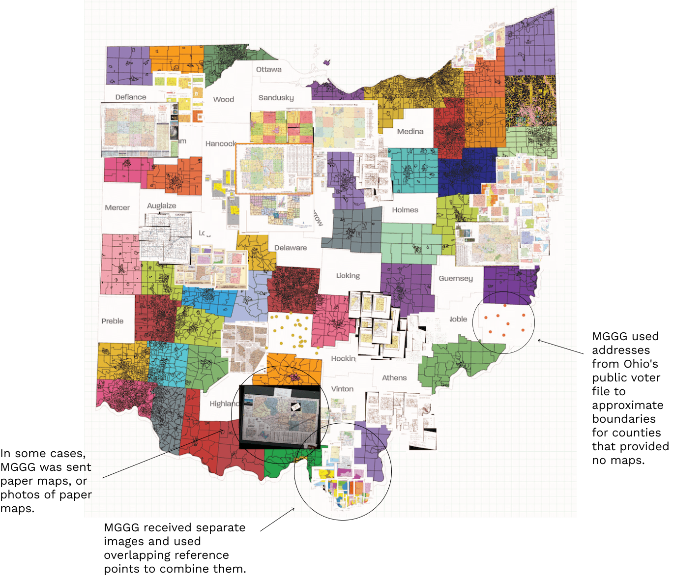
Precinct boundaries may be shared through various formats. In redistricting, the preferred format is often a shapefile, which can be readily imported into mapping and redistricting software. Generally, only election authorities with higher budgets maintain their precinct boundaries as shapefiles. Local election authorities choose what format to maintain precinct boundaries in, so sometimes this data is only available as a PDF, or on a map pinned on someone’s cubicle wall. A single state may contain all of these formats and more.
In addition, there is often little to no standardization of naming conventions, how data must be maintained, or the times at which an election authority can redraw the boundaries. All of these factors make it difficult to ascertain whether a statewide precinct boundary file is up-to-date.
Although local election authorities often report in-person votes at the precinct level, this is not always the case for absentee, provisional, and military or overseas ballots. Although the election authority uses a voter’s US address to send them the correct ballot, the results are not always reported at the precinct associated with their address, but under an “Early Voting” precinct that does not exist in physical space. This means that the number of “precincts” that are listed in election results may not match the number of actual voting precincts represented in a precinct boundary file.
After an election, results are tabulated and then submitted by the local election authorities to a state-level authority, typically the Secretary of State, to finalize the results by informal and formal deadlines. The state-level authority then chooses how to process and release the data. Certain states combine data from local election authorities and release statewide files with some standardization of results. This data requires much less processing to be usable. Other states make data available for download at the county or county-equivalent level. Combining these files takes much more effort, as non-digitized files have to be converted into digital versions, and all files must be converted into the same file format to create a state-wide shapefile.
How are precinct boundary data collected and processed by our partners?
Due to the variations in how precinct boundaries and election results are reported and stored in a single state, cobbling together a statewide dataset is a laborious task. Our data partners collect this data from both state and county sources.
If statewide precinct boundaries are not available from a single source, data partners reach out to individual local election authorities to retrieve whatever data they have (shapefiles, maps, lists of addresses, etc.). When contacting the counties, data partners ask for their current precinct plans and how long they have been in effect. They also ask about older copies of precinct plans. Previous precinct boundaries can be particularly difficult to acquire because once new boundaries are established, the old ones are erased shortly after. Occasionally, physical copies of maps or CDs of data have to be mailed, and sometimes the requested plans or data can only be sent to a registered voter in their county.
How are precinct boundaries combined into one state-level shapefile?
Once precinct boundary data has been procured from local election authorities, our partners face the complicated task of creating a state-wide shapefile. Since not all of the data comes in shapefiles, some data must be transformed to a shapefile through digitization, georeferencing, or other methods. All of the local plans need to be combined to create a single statewide shapefile.
An alternative method data partners may use to reconstruct approximate precinct boundaries from voter file data is looking at voter addresses and what precinct they are assigned to. Then, our data partners match these potential boundaries with election results.
How are election results data collected?
Unlike precinct boundaries, election results are maintained by the state, typically in the Secretary of State’s office. Data collection partners will retrieve election results from sources such as a Secretary of State’s office, MIT Election Data and Science Lab (MEDSL), and Open Elections.
How are precinct boundaries joined with election results?
In order to join precinct boundary geographies to election results, both files must have the same number of precincts. Data collection partners will assign early votes reported at county levels (such as absentee votes) to the other precincts in the county based on methods such as voting age population, candidate performance, or others. To further address discrepancies, data collection partners sometimes merge or split precincts in a precinct boundary file to make sure the number of precincts match up with election results.
Furthermore, each precinct must also be assigned a unique name. Because elections are run by local authorities, precincts may have a unique identifier within a county, but not within a state. It is quite common for a state to have multiple precincts with the same name. Additional processing is required to ensure a unique identifier field in both the boundary file and the election results.
How are the data used in redistricting?
Various criteria in redistricting can only be met using precinct boundaries and election results. At the federal level, the combined precinct boundary and election results shapefiles are useful for Racially Polarized Voting RPV analysis and other analyses of the Voting Rights Act VRA. Precinct Boundary and Election Results files can be combined with demographic data to determine if Gingles 2 and 3 criteria are met. Since precincts are not Census geographies, there is no demographic or racial data that is readily available at the precinct level. One or both of the datasets must be aggregated or disaggregated to a common geography so they can be used in tandem. In some cases, though not always, Blocks and Block Groups are nested within precinct boundaries. In these cases, the demographic data can be aggregated to the precinct level without statistical weighting or other analyses.
Precinct boundaries and election results shapefiles are also important in determining compliance of proposed plans with certain state redistricting criteria. Some states require political competitiveness as a criteria in their districts, and each state defines ‘competitiveness’ differently. Precinct boundaries and election results can be aggregated to proposed districts for a given election/year.
In addition to determining compliance with the VRA or state criteria, precinct boundaries and election results can be used in automated redistricting practices. Some data partners may modify precinct boundaries to make them compatible with multiple election years to be used in additional research.
How is this data validated?
At the Redistricting Data Hub, we work to validate precinct boundaries and election results datasets produced by our data partners through our Partner Data Validation project.
Where can the data be found on the Redistricting Data Hub website?
You can find precinct boundaries and election results datasets on our website on each of the state pages for which they are available. To quickly find them, you can search “precinct” or “election” in the search bar on the state page, or filter by type of data for “precinct and election results”. The data are sometimes called precinct and election results on the RDH website. If you are interested in a dataset produced by a particular data partner, you can sort by source: MGGG, PGP, or VEST.
Do you have more questions?
Our help desk team can answer your questions about redistricting data and the redistricting process. Send a message and they will respond within one buisness day!